Ames Street Plant Campus: Difference between revisions
From Taylor Wiki
No edit summary |
No edit summary |
||
| Line 57: | Line 57: | ||
<div style="font-size: 2.2rem; margin-bottom: 8px;">📍</div> | <div style="font-size: 2.2rem; margin-bottom: 8px;">📍</div> | ||
<div style="font-family: Georgia, serif; font-size: 1.35rem; font-weight: bold; color: #ffffff; margin-bottom: 6px;">95 Ames Street, Rochester, NY 14611</div> | <div style="font-family: Georgia, serif; font-size: 1.35rem; font-weight: bold; color: #ffffff; margin-bottom: 6px;">95 Ames Street, Rochester, NY 14611</div> | ||
<div style="color: #cbd5e1; font-size: 0.9rem; max-width: 580px; margin: 0 auto 16px auto; line-height: 1.5;">Coordinates: 43. | <div style="color: #cbd5e1; font-size: 0.9rem; max-width: 580px; margin: 0 auto 16px auto; line-height: 1.5;">Coordinates: 43.151074° N, 77.644416° W • Monroe County • Historic 19th Ward / West Side Industrial Corridor</div> | ||
<div style="display: flex; flex-wrap: wrap; justify-content: center; gap: 12px;"> | <div style="display: flex; flex-wrap: wrap; justify-content: center; gap: 12px;"> | ||
<span class="plainlinks">[https://www.openstreetmap.org/?mlat=43. | <span class="plainlinks">[https://www.openstreetmap.org/?mlat=43.151074&mlon=-77.644416#map=17/43.151074/-77.644416 <span style="display: inline-block; background: #c5a059; color: #14153a; font-weight: 700; font-size: 0.88rem; padding: 8px 18px; border-radius: 4px; text-decoration: none;">🗺 Open in OpenStreetMap ↗</span>]</span> | ||
<span class="plainlinks">[https://www.google.com/maps/search/?api=1&query=43. | <span class="plainlinks">[https://www.google.com/maps/search/?api=1&query=43.151074,-77.644416 <span style="display: inline-block; background: #ffffff; color: #14153a; font-weight: 700; font-size: 0.88rem; padding: 8px 18px; border-radius: 4px; text-decoration: none;">🌐 Open in Google Maps ↗</span>]</span> | ||
<span class="plainlinks">[https://maps.cityofrochester.gov/historic/ <span style="display: inline-block; background: transparent; border: 1px solid #c5a059; color: #f5f0e6; font-weight: 700; font-size: 0.88rem; padding: 8px 18px; border-radius: 4px; text-decoration: none;">🏛 Rochester Historic Map Viewer ↗</span>]</span> | <span class="plainlinks">[https://maps.cityofrochester.gov/historic/ <span style="display: inline-block; background: transparent; border: 1px solid #c5a059; color: #f5f0e6; font-weight: 700; font-size: 0.88rem; padding: 8px 18px; border-radius: 4px; text-decoration: none;">🏛 Rochester Historic Map Viewer ↗</span>]</span> | ||
</div> | </div> | ||
| Line 69: | Line 69: | ||
</div> | </div> | ||
</div> | </div> | ||
Revision as of 18:50, 28 October 2026
HEADQUARTERS & MANUFACTURING COMPLEX • 95 AMES STREET
Ames Street Plant & Campus
The historic 300,000+ sq. ft. precision manufacturing headquarters in Rochester, New York—from agricultural tracts in 1900 to peak industrial expansion and modern satellite outlines.
Evolution of the 95 Ames Street Campus
Following the rapid growth of the Taylor Brothers Company and the 1907 consolidation of Taylor Instrument Companies, the firm acquired property along Ames Street, Hague Street, and the New York Central Railroad mainline. The facility grew to encompass extensive machine shops, glass-blowing departments, plating rooms, an employee athletic field, tennis courts, and a prominent rooftop meteorological observatory dome.
Interactive research resource: City of Rochester Historic Map Viewer (External Interactive Plat Maps) →
Plant Campus Architecture & Aerial Views
The full manufacturing perimeter, railway spur, industrial water tower, and community athletic facilities.
-
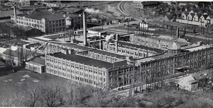 Ames Street Plant & Campus (Aerial Overview)
Comprehensive view showing the multi-story comb-tooth wings, rooftop weather dome, water tower, and foreground athletic field. -
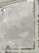 Cleared Site (2021 Aerial Imagery)
Modern satellite view of the cleared 95 Ames Street parcel; outlines of the factory foundations and rail spur remain visible.


Cartographic History (Plat Map Progression 1900–1935)
Historic insurance and city plat maps tracking the acquisition and footprint expansion of the Taylor campus across 35 years.
-
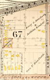 Pre-Industrial Parcels (1900 Plat Map)
The Ames, Hague, and West Avenue tract prior to Taylor factory construction, largely divided into residential parcels. -
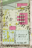 Initial Plant Footprint (1910 Plat Map)
Early Taylor Instrument Companies manufacturing facility featuring early manufacturing wings along Ames Street. -
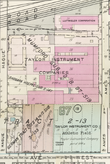 Peak Industrial Expansion (1935 Plat Map)
Full industrial campus buildout including plant additions, railway siding, and the Taylor Athletic Field along West Avenue.


Modern Geographic Location
The historic Taylor campus occupied the superblock bordered by Ames Street, West Avenue, Hague Street, and the New York Central Railroad mainline.
Related Architectural & Manufacturing Records
Explore internal views of the production facilities or review career histories of those who worked at Ames Street:

